14 March 2026
15 March is the backup date
Tararua Mountain race 20 per cent chance of sun, 10 per cent chance of no wind, 100 per cent chance of blood, sweat and tears.
Field Dash 13KM 770M
This race starts at Otaki Forks
The route heads up the track to field hut and returns on the same route. In distance, the track is 13km and the total ascent is 770m.
The descent involves a mix of tree-roots and mud or slippery clay. There are some good sections along here and it is all able to be run.
The finish at Otaki Forks, on the grassy flats of the Waiotaruru River, is reached after a short grass covered plateau followed by crossing the river over the foot bridge
Price $90
Kime Climb 24KM 1300M
This race starts at Otaki Forks
The route heads up the track to field hut and opens up above the bush line at table top where you climb up to Kime Hut In distance, the track is 24km and the total asccent is 1300m.
From Kime Hut, from there is a long and steep descent, to the finish at Otaki Forks.
The descent involves initially a rocky track above the tree line which, once entering the bust at Field Hut, transforms into a mix of tree-roots and mud or slippery clay. There are some good sections along here and it is all able to be run.
The finish at Otaki Forks, on the grassy flats of the Waiotaruru River, is reached after a short grass covered plateau followed by crossing the river over the foot bridge.
Price $120
Kime Climb Route
The Southern Crossing 36KM 2300M
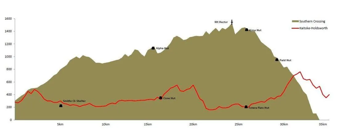
This race traverses the Southern Crossing tramping route which is the classic Tararua route from Kaitoke to Otaki Forks, transforming the 3-day hard tramp into a 1-day mountain run of epic proportions.
The 35km event is defined by the weather conditions. The Tararua Mountain Range is notoriously changeable environment, with high winds and low cloud being common for a 10km section of the race when above the bushline. Extreme care is required.
Participants start the Southern Crossing in waves, depending on their estimated finish time, those aiming for a fast time start later in the morning. We offer transport options from the finish to the start. We are asking runners to car pool or use the train to Maymorn and a short taxi ride to get to the start.
In distance, the track is 35.4km and the total asccent is 2,250m. The total descent is 2,475m.
The first part of the race, 16.43km to Alpha Hut, is the hardest, both physically and mentally. Initially, the climb from Kaitoke is of moderate steepness and, if it hasn't rained too much, is reasonable good underfoot, although it tends to be a bit "clayey". There is a short flattish section after about 6km which opens out for some great views, but after that you plunge back into the trees where there is deep mud, tree roots, steep ascents and the interminable Marchant Ridge, before you reach Alpha Hut, just at the break of the tree line.
From the check point at Alpha Hut the route is above the bush line and traverses various peaks and knobs to the highest and most exposed point at Mt Hector (1,529m). After one more climb over Field Peak you reach Kime Hut, a total of 8.2km from Alpha Hut. From there is a long and steep descent, of 10.8km, to the finish at Otaki Forks.
The descent involves initially a rocky track above the tree line which, once entering the bust at Field Hut, transforms into a mix of tree-roots and mud or slippery clay. There are some good sections along here and it is all able to be run.
The finish at Otaki Forks, on the grassy flats of the Waiotaruru River, is reached after a short grass covered plateau followed by crossing the river over the foot bridge.
Prices
Earlybird (First 30) $159
Standard $199
Late Entry (From March 1) $249
Team Prices
Earlybird (By 31/12) $299
Standard $359
Late Entry (From March 1) $459
Southern Crossing Route

Video from the 2015 Event
Thank you to our sponsors


Contact Andy [email protected]
